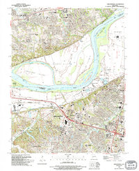
1994 Map of Chesterfield
USGS Topo · Published 1995About this map
The Missouri River carves a massive arc through this landscape, separating the floodplain agricultural lands of St Charles and St Louis Counties. The valley floor is dominated by complex fluvial features including Bonhomme Island and Catfish Island, protected by an extensive network of levees. On the southern bluffs, the transition from rural to suburban is evident in the development of Chesterfield and Clarkson Valley.
Find a feature on this map
55 named features on this map. Tap any name to fly to it.
Don’t see what you’re looking for? This feature index may not catch every label — zoom into the map to look around manually.
Map Details
Editions of this 1994 Chesterfield Map
This is the sole edition of this map. No revisions or reprints were ever made.
Other maps of this area

1903 · O'Fallon
USGS Topo · 1:125,000

1924 · Robertson
USGS Topo · 1:24,000

1927 · St. Charles
USGS Topo · 1:62,500

1931 · Manchester SE
USGS Topo · 1:24,000

1931 · Brussels
USGS Topo · 1:62,500

1932 · Manchester NE
USGS Topo · 1:24,000

1933 · Creve Coeur
USGS Topo · 1:24,000

1933 · Saint Charles
USGS Topo · 1:62,500

1933 · Kirkwood
USGS Topo · 1:24,000

1937 · Weldon Spring
USGS Topo · 1:24,000