1920 Map of Chestertown
USGS Topo · Published 1920About this map
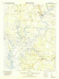
Chestertown and Centerville anchor this 1920 military survey of the Eastern Shore, illustrating a landscape defined by its intricate peninsulas and landings. The map reveals a sophisticated maritime-dependent economy, with numerous family-named wharves and landings such as Vickers Whf, Learys Mill Whf, and Bogles Wharf dotting the shorelines of Langford Bay and the Chester River. These points served as vital interfaces between the agricultural interior and Chesapeake Bay shipping routes.
Find a feature on this map
133 named features on this map. Tap any name to fly to it.
Don’t see what you’re looking for? This feature index may not catch every label — zoom into the map to look around manually.
Map Details
Editions of this 1920 Chestertown Map
This is the sole edition of this map. No revisions or reprints were ever made.
Other maps of this area

1892 · Annapolis
USGS Topo · 1:62,500

1893 · North Point
USGS Topo · 1:62,500

1893 · Gunpowder
USGS Topo · 1:62,500

1898 · Choptank
USGS Topo · 1:125,000

1898 · Tolchester
USGS Topo · 1:125,000

1899 · Dover
USGS Topo · 1:125,000

1900 · Cecilton
USGS Topo · 1:62,500

1900 · Betterton
USGS Topo · 1:62,500
1901 · Chestertown
USGS Topo · 1:62,500

1901 · Gunpowder
USGS Topo · 1:62,500