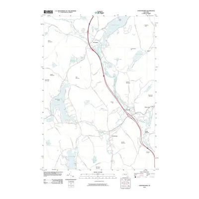
2010 Map of Chestertown
USGS Topo · Published 2010About this map
Chestertown serves as a central hub in this landscape of the southeastern Adirondacks, where the Schroon River winds through a complex network of glacial lakes and granite peaks. The settlement pattern follows the water and the narrow valleys, with Pottersville situated near the southern tip of Schroon Lake and Starbuckville positioned further downstream. Local roads like White Schoolhouse Rd and Landon Hill Rd connect these hamlets, reflecting a history of small-scale agriculture and timber harvesting amidst the peaks of Panther Mountain and Kipp Mountain.
Find a feature on this map
81 named features on this map. Tap any name to fly to it.
Don’t see what you’re looking for? This feature index may not catch every label — zoom into the map to look around manually.
Map Details
Editions of this 2010 Chestertown Map
This is the sole edition of this map. No revisions or reprints were ever made.
Other maps of this area

1895 · North Creek
USGS Topo · 1:62,500

1895 · Paradox Lake
USGS Topo · 1:62,500

1897 · Bolton
USGS Topo · 1:62,500

1897 · Paradox Lake
USGS Topo · 1:62,500

1897 · North Creek
USGS Topo · 1:62,500

1897 · Schroon Lake
USGS Topo · 1:62,500

1900 · Bolton
USGS Topo · 1:62,500

1950 · Glens Falls
USGS Topo · 1:250,000
1953 · Paradox Lake
USGS Topo · 1:62,500

1953 · Schroon Lake
USGS Topo · 1:62,500