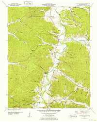
1950 Map of Chestnut Grove
USGS Topo · Published 1953About this map
The Buffalo River winds through a landscape defined by deep hollows and family-named ridges in this mid-century survey. Settlement patterns are concentrated along the river valley and the many narrow creek branches, where small communities like Beardstown and Chestnut Grove serve as local anchors. The map reveals an intricate network of rural life, with numerous small burial grounds such as DePriest Cem, Burns Cem, and Johnson Cem scattered among the timbered slopes. Education and faith are represented by landmarks like the Parnell School and Fairview Ch, providing a clear view of the social geography before modern infrastructure bypassed these smaller centers. On the western heights, the Linden Lookout Tower stands as a sentinel over the watersheds of Lick Creek and North Fork Toms Creek. The terrain is particularly steep at Scaggs Bluff, showing the challenging topography that shaped local road development and farming in Perry County.
Find a feature on this map
69 named features on this map. Tap any name to fly to it.
Don’t see what you’re looking for? This feature index may not catch every label — zoom into the map to look around manually.
Map Details
Editions of this 1950 Chestnut Grove Map
3 editions found
Other maps of this area

1936 · Graves Spring
USGS Topo · 1:24,000

1936 · Pleasantville
USGS Topo · 1:24,000

1936 · Coble
USGS Topo · 1:24,000

1936 · Pine View
USGS Topo · 1:24,000

1936 · Daniels Landing
USGS Topo · 1:24,000

1936 · Linden
USGS Topo · 1:24,000

1936 · Chestnut Grove
USGS Topo · 1:24,000

1936 · Lobelville
USGS Topo · 1:24,000

1936 · Pope
USGS Topo · 1:24,000
1949 · Pope
USGS Topo · 1:24,000