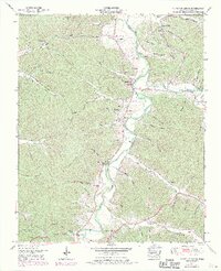
1950 Map of Chestnut Grove
USGS Topo · Published 1970About this map
The Buffalo River meanders through the heart of Perry County, its winding path punctuated by river markers and historic crossings like DePriest Bend. This mid-century survey reveals a landscape defined by its deep hollows and family-named ridges, where small communities like Beardstown and Chestnut Grove served as local hubs. For genealogists, the map is remarkably detailed, noting numerous family burial grounds including Harris Cem, Johnson Cem, and Taylor Cem. The presence of the Linden Lookout Tower near Ledbetter Hollow highlights the importance of forestry in the region during the 1950s. Farther south, cultural landmarks like Fairview Ch and Warren Ch anchor the rural neighborhoods, while natural features like Warren Cave and Twomey Spring provide a sense of the area's karst topography.
Find a feature on this map
74 named features on this map. Tap any name to fly to it.
Don’t see what you’re looking for? This feature index may not catch every label — zoom into the map to look around manually.
Map Details
Editions of this 1950 Chestnut Grove Map
3 editions found
Other maps of this area

1936 · Graves Spring
USGS Topo · 1:24,000

1936 · Pleasantville
USGS Topo · 1:24,000

1936 · Coble
USGS Topo · 1:24,000

1936 · Pine View
USGS Topo · 1:24,000

1936 · Daniels Landing
USGS Topo · 1:24,000

1936 · Linden
USGS Topo · 1:24,000

1936 · Chestnut Grove
USGS Topo · 1:24,000

1936 · Lobelville
USGS Topo · 1:24,000

1936 · Pope
USGS Topo · 1:24,000
1949 · Pope
USGS Topo · 1:24,000