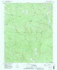
1993 Map of Chestnut Mountain
USGS Topo · Published 1995About this map
Pisgah National Forest encompasses the vast majority of this landscape, where the convergence of Avery, Burke, and Caldwell counties creates a complex terrain of ridges and deep drainage basins. High points like Headquarters Mtn and Chestnut Mtn overlook a network of watercourses including Wilson Creek and Steels Creek. The map shows human imprints within the forest, from the small settlement at Mortimer near the Ranger Station to the secluded Kawana community. These mountain communities and isolated landmarks like the Lookout Tower on Chestnut Mtn represent the mid-century intersection of forest management and rural Appalachian life. Local history and genealogy are anchored in features such as Parks Cem and the primitive trail identified as the Old Way, which suggest long-standing movement patterns through the Blue Ridge gaps.
Find a feature on this map
49 named features on this map. Tap any name to fly to it.
Don’t see what you’re looking for? This feature index may not catch every label — zoom into the map to look around manually.
Map Details
Editions of this 1993 Chestnut Mountain Map
This is the sole edition of this map. No revisions or reprints were ever made.
Other maps of this area

1893 · Cranberry
USGS Topo · 1:125,000

1895 · Cranberry
USGS Topo · 1:125,000

1899 · Cranberry
USGS Topo · 1:125,000

1902 · Cranberry
USGS Topo · 1:125,000

1905 · Morganton
USGS Topo · 1:125,000

1934 · Linville Falls
USGS Topo · 1:24,000

1934 · Newland
USGS Topo · 1:24,000

1936 · Blowing Rock
USGS Topo · 1:48,000

1942 · Blowing Rock
USGS Topo · 1:62,500

1944 · Linville
USGS Topo · 1:62,500