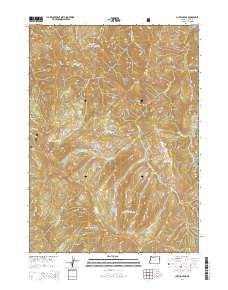
2014 Map of Chetco Peak
USGS Topo · Published 2014About this map
Siskiyou National Forest dominates this high-altitude landscape in Curry County, where the dramatic peaks and headwaters of several major river systems converge. The terrain is defined by prominent summits such as Chetco Peak and Vulcan Peak, providing a detailed look at the drainage patterns of the Chetco River and its various tributaries including the S Fork Chetco River. This 2014 survey documents the hydrography of the region's high lakes, including Chetco Lake, Vulcan Lake, and the remote Salamander Lake. The map captures the complex system of creeks like Box Canyon Cr and Brokenear Cr that feed the river network, showing the area's natural state within the national forest boundaries. For researchers of Oregon's wilderness history, it offers precise locations of physical landmarks like Moores Ridge and Red Mtn.
Find a feature on this map
28 named features on this map. Tap any name to fly to it.
Don’t see what you’re looking for? This feature index may not catch every label — zoom into the map to look around manually.
Map Details
Editions of this 2014 Chetco Peak Map
This is the sole edition of this map. No revisions or reprints were ever made.
Other maps of this area

1917 · Kerby
USGS Topo · 1:125,000

1918 · Kerby
USGS Topo · 1:125,000

1945 · Kerby
USGS Topo · 1:125,000

1954 · Coos Bay
USGS Topo · 1:250,000

1954 · Chetco Peak
USGS Topo · 1:62,500

1954 · Collier Butte
USGS Topo · 1:62,500

1954 · Mt. Emily
USGS Topo · 1:62,500

1954 · Pearsoll Peak
USGS Topo · 1:62,500

1955 · Medford
USGS Topo · 1:250,000

1957 · Medford
USGS Topo · 1:250,000