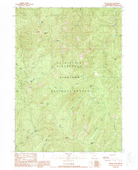
1989 Map of Chetco Peak
USGS Topo · Published 1989About this map
Kalmiopsis Wilderness defines this portion of the Siskiyou National Forest, where the complex drainage of the Chetco River meets the headwaters of the North Fork Smith River. The landscape is dominated by high summits including Chetco Peak, Vulcan Peak, and Red Mountain. Small alpine waters like Vulcan Lake and Lish Lake are scattered among the steep ridges. Human activity is recorded primarily through isolated sites and legacy infrastructure, such as the Gardner Mine tucked behind Moores Ridge. Multiple former habitations and outposts are noted, including Madstone Cabin (Site), Fresno Camp (Site), and Cottonwood Camp (Site), marking the locations of backcountry camps and cabins that once supported forest management or mineral exploration in this protected corner of Curry County.
Find a feature on this map
32 named features on this map. Tap any name to fly to it.
Don’t see what you’re looking for? This feature index may not catch every label — zoom into the map to look around manually.
Map Details
Editions of this 1989 Chetco Peak Map
This is the sole edition of this map. No revisions or reprints were ever made.
Other maps of this area

1917 · Kerby
USGS Topo · 1:125,000

1918 · Kerby
USGS Topo · 1:125,000

1945 · Kerby
USGS Topo · 1:125,000

1954 · Coos Bay
USGS Topo · 1:250,000

1954 · Chetco Peak
USGS Topo · 1:62,500

1954 · Collier Butte
USGS Topo · 1:62,500

1954 · Mt. Emily
USGS Topo · 1:62,500

1954 · Pearsoll Peak
USGS Topo · 1:62,500

1955 · Medford
USGS Topo · 1:250,000

1957 · Medford
USGS Topo · 1:250,000