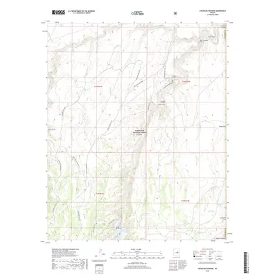
2018 Map of Chevelon Crossing
USGS Topo · Published 2018About this map
Sitgreaves National Forest dominates this high-altitude landscape where the drainage systems of the Mogollon Plateau meet the deep incisions of Chevelon Creek. The map documents a rugged interior defined by complex canyon topography, including Elk Rub Canyon, Alder Canyon, and West Chevelon Canyon. At the heart of the quadrangle, Chevelon Crossing serves as a critical waypoint near the confluence of several major draws. Resource management and recreation are evident through the extensive Long Draw OHV Loop and a network of water catchment systems like Durfee Tank and Standard Tank. These features, along with Chevelon Lake and Chevelon Canyon Lake, illustrate the vital role of water infrastructure in this arid forest environment during the early 21st century.
Find a feature on this map
31 named features on this map. Tap any name to fly to it.
Don’t see what you’re looking for? This feature index may not catch every label — zoom into the map to look around manually.
Map Details
Editions of this 2018 Chevelon Crossing Map
This is the sole edition of this map. No revisions or reprints were ever made.
Other maps of this area

1886 · Holbrook
USGS Topo · 1:250,000

1893 · Holbrook
USGS Topo · 1:250,000

1954 · Holbrook
USGS Topo · 1:250,000

1957 · Holbrook
USGS Topo · 1:250,000

1958 · Holbrook
USGS Topo · 1:250,000

1960 · Holbrook
USGS Topo · 1:250,000

1961 · Woods Canyon
USGS Topo · 1:62,500

1961 · Heber
USGS Topo · 1:62,500
1965 · Grama Draw
USGS Topo · 1:24,000

1965 · Chevelon Crossing
USGS Topo · 1:24,000