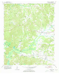
1951 Map of Chewalla
USGS Topo · Published 1973About this map
Chewalla and the surrounding borderlands of southern McNairy County are captured here just after mid-century, defined by a landscape of small rural settlements and an extensive network of waterways. The Southern railroad serves as a primary corridor through the area, passing through Chewalla and near the high ground of Kings Mountain. The geography is notably shaped by the meandering Tuscumbia River and its accompanying Tuscumbia River Canal, alongside the broad Dismal Swamp to the west.
Find a feature on this map
45 named features on this map. Tap any name to fly to it.
Don’t see what you’re looking for? This feature index may not catch every label — zoom into the map to look around manually.
Map Details
Editions of this 1951 Chewalla Map
5 editions found
Other maps of this area

1936 · Purdy
USGS Topo · 1:24,000

1949 · Purdy
USGS Topo · 1:24,000

1950 · Corinth
USGS Topo · 1:62,500

1950 · Pocahontas
USGS Topo · 1:24,000

1950 · Hornsby
USGS Topo · 1:24,000

1951 · Hornsby
USGS Topo · 1:24,000

1951 · Chewalla
USGS Topo · 1:24,000

1951 · Guys
USGS Topo · 1:24,000

1951 · Rose Creek
USGS Topo · 1:24,000

1951 · Walnut
USGS Topo · 1:62,500