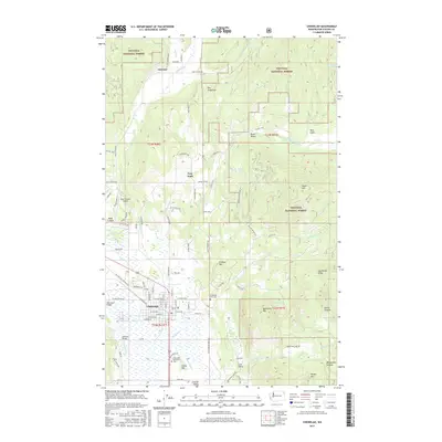
2017 Map of Chewelah
USGS Topo · Published 2017About this map
Chewelah serves as the central hub of this Stevens County landscape, where the Colville River flows through the fertile Colville Valley. The town's grid is well-defined, bordered by significant landmarks like the Chewelah City Cem and the Chewelah Memorial Park. To the west, the Sand Canyon Airport sits near the winding roads of Sand Canyon, while the eastern horizon is dominated by the steep rises of Quartzite Mtn and Jay Gould Ridge within the Colville National Forest.
Find a feature on this map
100 named features on this map. Tap any name to fly to it.
Don’t see what you’re looking for? This feature index may not catch every label — zoom into the map to look around manually.
Map Details
Editions of this 2017 Chewelah Map
This is the sole edition of this map. No revisions or reprints were ever made.
Other maps of this area

1927 · Chewelah
USGS Topo · 1:125,000

1930 · Chewelah
USGS Topo · 1:125,000

1958 · Sandpoint
USGS Topo · 1:250,000

1963 · Sandpoint
USGS Topo · 1:250,000

1964 · Chewelah
USGS Topo · 1:24,000

1964 · Cliff Ridge
USGS Topo · 1:24,000
1964 · Calispell Peak
USGS Topo · 1:24,000

1964 · Goddards Peak
USGS Topo · 1:24,000

1964 · Chewelah Mtn
USGS Topo · 1:62,500

1965 · Waitts Lake
USGS Topo · 1:24,000