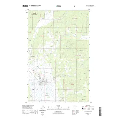
2020 Map of Chewelah
USGS Topo · Published 2020About this map
Chewelah serves as the primary hub of this 2020 Stevens County landscape, situated along the Colville River and organized around a structured grid of streets including Main Avenue and Lincoln Avenue. The area reflects a blend of rural residential pockets and public lands, with the Colville National Forest covering significant portions of the surrounding highlands. Local history and genealogy are preserved at the Saint Mary of the Rosary Catholic Cem and Chewelah Memorial Park, while transportation infrastructure is marked by Sand Canyon Airport and historic river crossings like Steinmetz Bridge and Klavano Bridge. The terrain transitions from the river valley to prominent heights such as Quartzite Mtn and Eagle Mtn, punctuated by smaller named settlements like Fairview and the interestingly titled The Tinderbox.
Find a feature on this map
46 named features on this map. Tap any name to fly to it.
Don’t see what you’re looking for? This feature index may not catch every label — zoom into the map to look around manually.
Map Details
Editions of this 2020 Chewelah Map
This is the sole edition of this map. No revisions or reprints were ever made.
Other maps of this area

1927 · Chewelah
USGS Topo · 1:125,000

1930 · Chewelah
USGS Topo · 1:125,000

1958 · Sandpoint
USGS Topo · 1:250,000

1963 · Sandpoint
USGS Topo · 1:250,000

1964 · Chewelah
USGS Topo · 1:24,000

1964 · Cliff Ridge
USGS Topo · 1:24,000
1964 · Calispell Peak
USGS Topo · 1:24,000

1964 · Goddards Peak
USGS Topo · 1:24,000

1964 · Chewelah Mtn
USGS Topo · 1:62,500

1965 · Waitts Lake
USGS Topo · 1:24,000