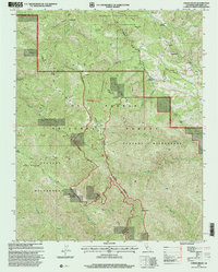
1995 Map of Chews Ridge
USGS Topo · Published 2000About this map
Mira Observatory stands prominently atop the high ridges of the Santa Lucia Range, marking a landscape of significant elevation changes and deep drainage basins. This mid-1990s revision of the Chew's Ridge area shows a complex network of private ranches and public lands, where the Ventana Wilderness meets the Los Padres National Forest. The settlement pattern is defined by isolated holdings like Rancho Palo Escrito, Cahoon Ranch, and the Mascorini Place, many accessible only by rugged routes like Tassajara Road or the Miller Canyon Trail. The geography is carved by steep watercourses such as Tassajara Creek and Arroyo Seco, reflecting an era where high-altitude scientific observation and traditional ranching coexisted within protected federal lands.
Find a feature on this map
47 named features on this map. Tap any name to fly to it.
Don’t see what you’re looking for? This feature index may not catch every label — zoom into the map to look around manually.
Map Details
Editions of this 1995 Chews Ridge Map
This is the sole edition of this map. No revisions or reprints were ever made.
Other maps of this area

1910 · Soledad
USGS Topo · 1:31,680

1915 · Soledad
USGS Topo · 1:62,500

1919 · Junipero Serra
USGS Topo · 1:62,500

1920 · Jamesburg
USGS Topo · 1:48,000

1921 · Jamesburg
USGS Topo · 1:62,500

1921 · Lucia
USGS Topo · 1:62,500

1939 · Jamesburg
USGS Topo · 1:62,500

1940 · Jamesburg
USGS Topo · 1:62,500

1940 · Soledad
USGS Topo · 1:62,500

1941 · Lucia
USGS Topo · 1:62,500