1940 Map of Soledad
USGS Topo · Published 1940About this map
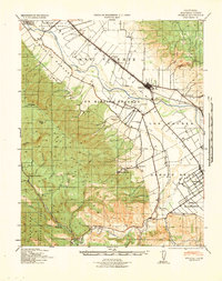
Mission Soledad (Ruins) stands as a focal point of this 1940 tactical survey, marking the intersection of Spanish-era land grants and the intensive agricultural development of the Salinas Valley. The map documents the vast expanses of the Ex Mission Soledad and Los Coches ranchos, where a network of irrigation through the Spreckels Canal and numerous pump houses supported the region's growth. The Southern Pacific railroad line links the settlements of Soledad and Greenfield, passing through smaller sidings like Camphora and Molus.
Find a feature on this map
42 named features on this map. Tap any name to fly to it.
Don’t see what you’re looking for? This feature index may not catch every label — zoom into the map to look around manually.
Map Details
Editions of this 1940 Soledad Map
This is the sole edition of this map. No revisions or reprints were ever made.
Other maps of this area

1910 · Gonzales
USGS Topo · 1:31,680

1910 · Salinas
USGS Topo · 1:31,680

1910 · Soledad
USGS Topo · 1:31,680

1912 · Salinas
USGS Topo · 1:62,500

1912 · Metz
USGS Topo · 1:31,680

1915 · Soledad
USGS Topo · 1:62,500

1919 · King City
USGS Topo · 1:62,500

1919 · San Benito
USGS Topo · 1:62,500

1919 · Junipero Serra
USGS Topo · 1:62,500

1920 · Jamesburg
USGS Topo · 1:48,000