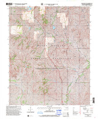
1998 Map of Cheyenne NW
USGS Topo · Published 2001About this map
Black Kettle National Grassland dominates this corner of Roger Mills County, illustrating a landscape managed for conservation and energy production at the close of the twentieth century. The terrain is marked by the winding course of the Washita River in the south and the smaller drainage of Dead Indian Creek to the north, where it feeds into Dead Indian Lake. This reservoir anchors the Black Kettle Recreation Area, complete with a Boat Ramp for public access. The map reveals the industrial footprint of the region through numerous Gas Well sites and a prominent Pipeline corridor that cuts through the grassland. The small community of Streeter sits at a crossroads, while a Gaging Station on the river and various 4wd tracks suggest a rural environment focused on water management and resource extraction.
Find a feature on this map
13 named features on this map. Tap any name to fly to it.
Don’t see what you’re looking for? This feature index may not catch every label — zoom into the map to look around manually.
Map Details
Editions of this 1998 Cheyenne NW Map
This is the sole edition of this map. No revisions or reprints were ever made.
Other maps of this area

1955 · Clinton
USGS Topo · 1:250,000

1957 · Clinton
USGS Topo · 1:250,000

1960 · Cheyenne
USGS Topo · 1:62,500

1961 · Reydon
USGS Topo · 1:62,500

1965 · Crawford
USGS Topo · 1:24,000

1966 · Roll
USGS Topo · 1:24,000

1966 · Roll SE
USGS Topo · 1:24,000

1984 · Foss Reservoir
USGS Topo · 1:100,000

1988 · Dempsey
USGS Topo · 1:24,000
1989 · Cheyenne NW
USGS Topo · 1:24,000