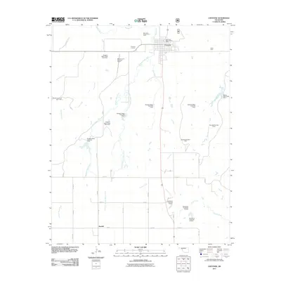
2011 Map of Cheyenne
USGS Topo · Published 2011About this map
Cheyenne serves as the regional hub in this part of western Oklahoma, situated just north of where the Washita River cuts across the landscape. The town is flanked by public service sites including the Black Kettle Ranger District Office and the Black Kettle Forest Service Facility, reflecting the area's significance to land management. To the south, the smaller settlement of Rosehill anchors the corner of a landscape defined by an extensive system of water management. Numerous flood control structures, such as Sargeant Major Creek Site 6 Dam and Sandstone Creek Site 114 Dam, are scattered along the tributaries like Sergeant Major Creek and Currant Creek. This network of small dams and reservoirs indicates a landscape heavily engineered to manage the flow of prairie streams into the larger river basin. Local landmarks like the Cheyenne Cemetery and Mignon Laird Municipal Airport provide specific points of interest for genealogists and local historians.
Find a feature on this map
44 named features on this map. Tap any name to fly to it.
Don’t see what you’re looking for? This feature index may not catch every label — zoom into the map to look around manually.
Map Details
Editions of this 2011 Cheyenne Map
This is the sole edition of this map. No revisions or reprints were ever made.
Other maps of this area

1955 · Clinton
USGS Topo · 1:250,000

1957 · Clinton
USGS Topo · 1:250,000

1960 · Sweetwater
USGS Topo · 1:62,500

1960 · Cheyenne
USGS Topo · 1:62,500

1960 · Sayre
USGS Topo · 1:62,500

1961 · Reydon
USGS Topo · 1:62,500

1984 · Foss Reservoir
USGS Topo · 1:100,000

1985 · Elk City
USGS Topo · 1:100,000
1988 · Grimes
USGS Topo · 1:24,000

1988 · Dempsey
USGS Topo · 1:24,000