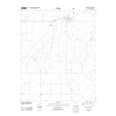
2012 Map of Cheyenne
USGS Topo · Published 2012About this map
The Washita River meanders across the northern portion of this landscape, just above the town of Cheyenne. This 2012 survey illustrates a classic Western Oklahoma drainage pattern, where numerous creeks including Sergeant Major Cr, Brokenleg Cr, and Plum Cr flow northward through a grid of section roads. The local aviation and community infrastructure is represented by the Mignon Laird Municipal Airport and the Cheyenne Cem, while the small settlement of Rosehill anchors the southern boundary of the map. The distribution of these watercourses and local landmarks reflects the agricultural and transport-oriented layout of Roger Mills County in the early twenty-first century.
Find a feature on this map
31 named features on this map. Tap any name to fly to it.
Don’t see what you’re looking for? This feature index may not catch every label — zoom into the map to look around manually.
Map Details
Editions of this 2012 Cheyenne Map
This is the sole edition of this map. No revisions or reprints were ever made.
Other maps of this area

1955 · Clinton
USGS Topo · 1:250,000

1957 · Clinton
USGS Topo · 1:250,000

1960 · Sweetwater
USGS Topo · 1:62,500

1960 · Cheyenne
USGS Topo · 1:62,500

1960 · Sayre
USGS Topo · 1:62,500

1961 · Reydon
USGS Topo · 1:62,500

1984 · Foss Reservoir
USGS Topo · 1:100,000

1985 · Elk City
USGS Topo · 1:100,000
1988 · Grimes
USGS Topo · 1:24,000

1988 · Dempsey
USGS Topo · 1:24,000