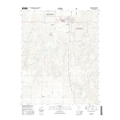
2016 Map of Cheyenne
USGS Topo · Published 2016About this map
Washita Battlefield National Historic Site anchors the northern portion of this landscape, marking a significant 1868 encounter along the Washita River. Surrounding the community of Cheyenne is the Black Kettle National Grassland, a patchwork of protected prairie that reflects federal conservation efforts in western Oklahoma. The map reveals an intricate water management system characterized by numerous upstream flood control structures, including Sargeant Major Creek Site 6 Reservoir and Sandstone Creek Site 115 Reservoir, which dot the drainages of Plum Creek and Currant Creek.
Find a feature on this map
46 named features on this map. Tap any name to fly to it.
Don’t see what you’re looking for? This feature index may not catch every label — zoom into the map to look around manually.
Map Details
Editions of this 2016 Cheyenne Map
This is the sole edition of this map. No revisions or reprints were ever made.
Other maps of this area

1955 · Clinton
USGS Topo · 1:250,000

1957 · Clinton
USGS Topo · 1:250,000

1960 · Sweetwater
USGS Topo · 1:62,500

1960 · Cheyenne
USGS Topo · 1:62,500

1960 · Sayre
USGS Topo · 1:62,500

1961 · Reydon
USGS Topo · 1:62,500

1984 · Foss Reservoir
USGS Topo · 1:100,000

1985 · Elk City
USGS Topo · 1:100,000
1988 · Grimes
USGS Topo · 1:24,000

1988 · Dempsey
USGS Topo · 1:24,000