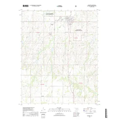
2018 Map of Cheyenne
USGS Topo · Published 2018About this map
Washita Battlefield National Historic Site anchors the northern landscape of this Roger Mills County survey, marking the site of the 1868 encounter between the U.S. Army and the Southern Cheyenne. The town of Cheyenne is positioned just southeast of the historic site, where residential streets like Columbia Ave and Blaine Ave meet the open grasslands. This high-plains terrain is deeply etched by the Washita River and its numerous tributaries, including Sergeant Major Cr and Brokenleg Cr, which define the drainage patterns of the region.
Find a feature on this map
44 named features on this map. Tap any name to fly to it.
Don’t see what you’re looking for? This feature index may not catch every label — zoom into the map to look around manually.
Map Details
Editions of this 2018 Cheyenne Map
This is the sole edition of this map. No revisions or reprints were ever made.
Other maps of this area

1955 · Clinton
USGS Topo · 1:250,000

1957 · Clinton
USGS Topo · 1:250,000

1960 · Sweetwater
USGS Topo · 1:62,500

1960 · Cheyenne
USGS Topo · 1:62,500

1960 · Sayre
USGS Topo · 1:62,500

1961 · Reydon
USGS Topo · 1:62,500

1984 · Foss Reservoir
USGS Topo · 1:100,000

1985 · Elk City
USGS Topo · 1:100,000
1988 · Grimes
USGS Topo · 1:24,000

1988 · Dempsey
USGS Topo · 1:24,000