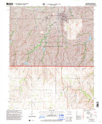
1998 Map of Cheyenne
USGS Topo · Published 2001About this map
The Washita River valley dominates this western Oklahoma landscape, a region deeply tied to 19th-century history. In the northern portion of the map, the Battle of the Washita Historical Marker commemorates a pivotal conflict between the U.S. Army and the Southern Cheyenne. Much of the surrounding area is protected as part of the Black Kettle National Grassland, where the Black Kettle Ranger District Office manages the vast shortgrass prairie terrain.
Find a feature on this map
23 named features on this map. Tap any name to fly to it.
Don’t see what you’re looking for? This feature index may not catch every label — zoom into the map to look around manually.
Map Details
Editions of this 1998 Cheyenne Map
This is the sole edition of this map. No revisions or reprints were ever made.
Other maps of this area

1955 · Clinton
USGS Topo · 1:250,000

1957 · Clinton
USGS Topo · 1:250,000

1960 · Sweetwater
USGS Topo · 1:62,500

1960 · Cheyenne
USGS Topo · 1:62,500

1960 · Sayre
USGS Topo · 1:62,500

1961 · Reydon
USGS Topo · 1:62,500

1984 · Foss Reservoir
USGS Topo · 1:100,000

1985 · Elk City
USGS Topo · 1:100,000
1988 · Grimes
USGS Topo · 1:24,000

1988 · Dempsey
USGS Topo · 1:24,000