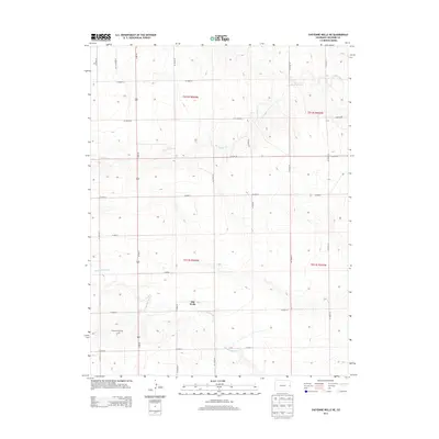
2013 Map of Cheyenne Wells NE
USGS Topo · Published 2013About this map
Old Wells sits near the southern edge of this High Plains landscape, where the ephemeral flow of the Smoky Hill River cuts through the shortgrass prairie of Cheyenne County. The terrain is defined by a series of gently sloping drainages, most notably Big Timber Cr which winds through the northern sections of the township. This area of eastern Colorado reflects a classic rural grid system, with an extensive network of numbered and lettered routes such as CO Road CC and CO Road AA facilitating travel across the agricultural expanses. Industrial activity is concentrated at the Cheyenne Oil Field in the southwest, showing the intersection of energy extraction and ranching. The presence of Us-385 N provides a primary north-south artery, connecting these isolated settlements and ranch lands to the broader region.
Find a feature on this map
25 named features on this map. Tap any name to fly to it.
Don’t see what you’re looking for? This feature index may not catch every label — zoom into the map to look around manually.
Map Details
Editions of this 2013 Cheyenne Wells NE Map
This is the sole edition of this map. No revisions or reprints were ever made.
Other maps of this area

1892 · Cheyenne Wells
USGS Topo · 1:125,000

1894 · Cheyenne Wells
USGS Topo · 1:125,000

1954 · Limon
USGS Topo · 1:250,000

1954 · Lamar
USGS Topo · 1:250,000

1957 · Limon
USGS Topo · 1:250,000

1958 · Limon
USGS Topo · 1:250,000

1958 · Lamar
USGS Topo · 1:250,000

1969 · Mount Sunflower SW
USGS Topo · 1:24,000

1969 · Burlington 3 SE
USGS Topo · 1:24,000
1969 · Burlington 3 SW
USGS Topo · 1:24,000