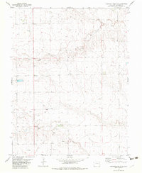
1982 Map of Cheyenne Wells NE
USGS Topo · Published 1982About this map
The Smoky Hill River winds through this section of the High Plains in eastern Colorado, defining a landscape marked by both historical frontier sites and modern resource extraction. This 1982 edition captures the area at a time when energy exploration was active, evidenced by the numerous Oil Wells and a Drill Hole scattered across the township lines. A significant historical anchor on the map is the Old Wells (Site), located north of the river near a local spring, indicating a former point of importance in this arid environment. The terrain is further etched by the drainage of Big Timber Creek to the north, while local industrial activity is noted by a Gravel Pit near the river valley. The map provides a clear view of the sparse but vital infrastructure of the early 1980s, from section-line roads to the specific fence lines that partitioned this ranching and oil country.
Find a feature on this map
9 named features on this map. Tap any name to fly to it.
Don’t see what you’re looking for? This feature index may not catch every label — zoom into the map to look around manually.
Map Details
Editions of this 1982 Cheyenne Wells NE Map
This is the sole edition of this map. No revisions or reprints were ever made.
Other maps of this area

1892 · Cheyenne Wells
USGS Topo · 1:125,000

1894 · Cheyenne Wells
USGS Topo · 1:125,000

1954 · Limon
USGS Topo · 1:250,000

1954 · Lamar
USGS Topo · 1:250,000

1957 · Limon
USGS Topo · 1:250,000

1958 · Limon
USGS Topo · 1:250,000

1958 · Lamar
USGS Topo · 1:250,000

1969 · Mount Sunflower SW
USGS Topo · 1:24,000

1969 · Burlington 3 SE
USGS Topo · 1:24,000
1969 · Burlington 3 SW
USGS Topo · 1:24,000