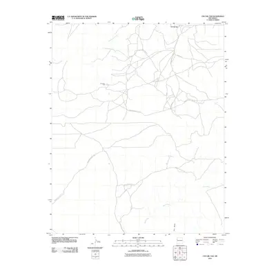
2010 Map of Chi Chil Tah
USGS Topo · Published 2010About this map
Chi Chil Tah is situated in a high-desert landscape defined by drainage systems and essential water sources, reflecting the rural infrastructure of the Eastern Navajo Agency in the early 21st century. The geography is anchored by the Whitewater Arroyo in the northwest and Bosson Wash to the south, with the prominent Zuni Buttes rising near the southern boundary. These natural landmarks are connected by a network of specialized roads, including Indian Service Route 7010 and Oak Mesa Rd, which facilitate movement across this arid terrain. A notable point of human activity in the center of the sheet is Stinkwater Well, a named water source that suggests the critical importance of groundwater management in this part of New Mexico. The map illustrates how transportation routes like Indian Service Route 11 follow the natural contours of the washes and arroyos, maintaining the connectivity of this community.
Find a feature on this map
11 named features on this map. Tap any name to fly to it.
Don’t see what you’re looking for? This feature index may not catch every label — zoom into the map to look around manually.
Map Details
Editions of this 2010 Chi Chil Tah Map
This is the sole edition of this map. No revisions or reprints were ever made.
Other maps of this area

1886 · Wingate
USGS Topo · 1:250,000

1886 · Fort Defiance
USGS Topo · 1:250,000

1892 · Fort Defiance
USGS Topo · 1:250,000

1892 · Wingate
USGS Topo · 1:250,000

1954 · Gallup
USGS Topo · 1:250,000

1958 · Gallup
USGS Topo · 1:250,000

1959 · Gallup
USGS Topo · 1:250,000

1962 · Gallup
USGS Topo · 1:250,000

1963 · Jones Ranch School
USGS Topo · 1:24,000
1963 · Vander Wagen
USGS Topo · 1:24,000
Featured Places
- Eastern Navajo Agency, NM
- Chi Chil Tah, Eastern Navajo Agency
- McKinley County, NM
- United States
- New Mexico