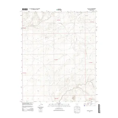
2013 Map of Chi Chil Tah
USGS Topo · Published 2013About this map
Cheechilgeetho stands at the northeastern edge of this landscape, a region defined by high-desert drainage systems and prominent landforms. The terrain is marked by the winding path of Whitewater Arroyo and the southern Bosson Wash, reflecting a hydrology where seasonal water flow is critical to local survival. Remote tracks like Oak Mesa Rd and Whitewater Canyon Rd provide the primary transit through the Eastern Navajo Agency, connecting isolated points of interest such as Stinkwater Well. The southern border is punctuated by the Zuñi Buttes, which serve as a distinctive geological landmark in an area otherwise dominated by the vast, open mesas of the Colorado Plateau. This documentation highlights the sparse infrastructure and essential water features that dictate the movement of people and livestock across this high-elevation terrain.
Find a feature on this map
18 named features on this map. Tap any name to fly to it.
Don’t see what you’re looking for? This feature index may not catch every label — zoom into the map to look around manually.
Map Details
Editions of this 2013 Chi Chil Tah Map
This is the sole edition of this map. No revisions or reprints were ever made.
Other maps of this area

1886 · Wingate
USGS Topo · 1:250,000

1886 · Fort Defiance
USGS Topo · 1:250,000

1892 · Fort Defiance
USGS Topo · 1:250,000

1892 · Wingate
USGS Topo · 1:250,000

1954 · Gallup
USGS Topo · 1:250,000

1958 · Gallup
USGS Topo · 1:250,000

1959 · Gallup
USGS Topo · 1:250,000

1962 · Gallup
USGS Topo · 1:250,000

1963 · Jones Ranch School
USGS Topo · 1:24,000
1963 · Vander Wagen
USGS Topo · 1:24,000
Featured Places
- Eastern Navajo Agency, NM
- Chi Chil Tah, Eastern Navajo Agency
- McKinley County, NM
- United States
- New Mexico