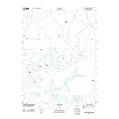
2011 Map of Chicamacomico River
USGS Topo · Published 2011About this map
The Chicamacomico River and Transquaking River dominate this low-lying landscape in Dorchester County, creating a complex network of waterways, marshes, and necks of land. Named necks such as Stanley Neck, Fork Neck, and Buzzard Neck define the local geography, reflecting a long history of water-dependent settlement. At the water's edge, sites like Cedar Landing and Brick House Landing point to the era when these rivers served as primary arteries for transport and commerce. Inland, the map shows several smaller water bodies including Savannah Lake and Parish Pond, interspersed with scattered homesteads and landings.
Find a feature on this map
46 named features on this map. Tap any name to fly to it.
Don’t see what you’re looking for? This feature index may not catch every label — zoom into the map to look around manually.
Map Details
Editions of this 2011 Chicamacomico River Map
This is the sole edition of this map. No revisions or reprints were ever made.
Other maps of this area

1898 · Choptank
USGS Topo · 1:125,000

1898 · St. Marys
USGS Topo · 1:125,000

1903 · Nanticoke
USGS Topo · 1:62,500

1904 · Oxford
USGS Topo · 1:62,500

1905 · Crapo
USGS Topo · 1:62,500

1905 · Hurlock
USGS Topo · 1:62,500

1906 · St. Marys
USGS Topo · 1:125,000

1908 · Choptank
USGS Topo · 1:125,000

1942 · Wetipquin
USGS Topo · 1:24,000
1942 · Wingate
USGS Topo · 1:24,000