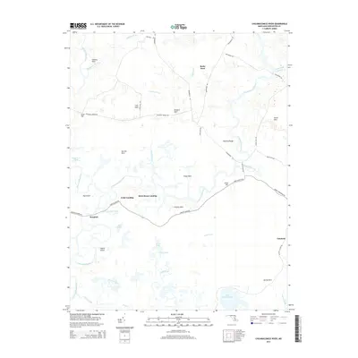
2014 Map of Chicamacomico River
USGS Topo · Published 2014About this map
Cedar Landing and Brick House Landing are key points of interest along this portion of the Chicamacomico River, where the Eastern Shore's marshy geography is defined by a series of named necks and reaches. The landscape is a complex network of wetlands and tidal tributaries, including Hurlock Creek and Beaverdam Creek, which separate distinct ridges of land such as Stanley Neck, Tripps Neck, and Griffith Neck. The interior topography reveals the agricultural and residential layout of rural Dorchester County, with small settlements like Bestpitch and Cokeland connected by long-established routes including Bestpitch Ferry Rd and Drawbridge Rd. The presence of numerous ponds and islands, such as Julie Pond and Chance Island, underscores the low-lying coastal character of this region, where land use is dictated by the surrounding water and expansive marsh areas like Manning Range.
Find a feature on this map
47 named features on this map. Tap any name to fly to it.
Don’t see what you’re looking for? This feature index may not catch every label — zoom into the map to look around manually.
Map Details
Editions of this 2014 Chicamacomico River Map
This is the sole edition of this map. No revisions or reprints were ever made.
Other maps of this area

1898 · Choptank
USGS Topo · 1:125,000

1898 · St. Marys
USGS Topo · 1:125,000

1903 · Nanticoke
USGS Topo · 1:62,500

1904 · Oxford
USGS Topo · 1:62,500

1905 · Crapo
USGS Topo · 1:62,500

1905 · Hurlock
USGS Topo · 1:62,500

1906 · St. Marys
USGS Topo · 1:125,000

1908 · Choptank
USGS Topo · 1:125,000

1942 · Wetipquin
USGS Topo · 1:24,000
1942 · Wingate
USGS Topo · 1:24,000