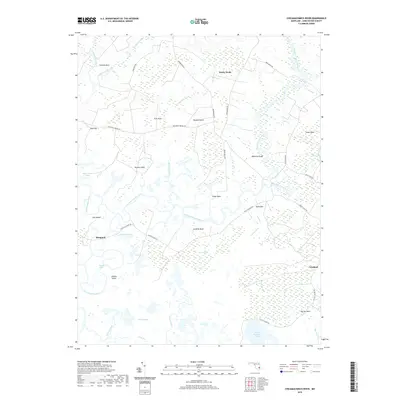
2019 Map of Chicamacomico River
USGS Topo · Published 2019About this map
The Chicamacomico River and Transquaking River dominate this Dorchester County landscape, defining a network of waterlogged peninsulas and marshes known locally as necks. Settlements such as Bestpitch and Cokeland sit at the edges of this tidewater environment, where the land frequently transitions into expansive wetlands like Thorofare Marsh and Guinea Marsh. The abundance of family-named features, including Hurlock Neck, Tripps Neck, and Griffith Neck, points to a long-standing pattern of coastal land tenure and agricultural isolation between the winding river branches. To the south, Little Savanna Lake and Doctors Creek highlight the intricate hydrology of the Chesapeake Bay's eastern shore, where roads like Bestpitch Ferry Rd and Elliott Island Rd provide the primary terrestrial links across the low-lying terrain. This modern survey reflects the enduring character of a region where tidal cycles and riverine flow continue to shape the boundaries of human settlement.
Find a feature on this map
47 named features on this map. Tap any name to fly to it.
Don’t see what you’re looking for? This feature index may not catch every label — zoom into the map to look around manually.
Map Details
Editions of this 2019 Chicamacomico River Map
This is the sole edition of this map. No revisions or reprints were ever made.
Other maps of this area

1898 · Choptank
USGS Topo · 1:125,000

1898 · St. Marys
USGS Topo · 1:125,000

1903 · Nanticoke
USGS Topo · 1:62,500

1904 · Oxford
USGS Topo · 1:62,500

1905 · Crapo
USGS Topo · 1:62,500

1905 · Hurlock
USGS Topo · 1:62,500

1906 · St. Marys
USGS Topo · 1:125,000

1908 · Choptank
USGS Topo · 1:125,000

1942 · Wetipquin
USGS Topo · 1:24,000
1942 · Wingate
USGS Topo · 1:24,000