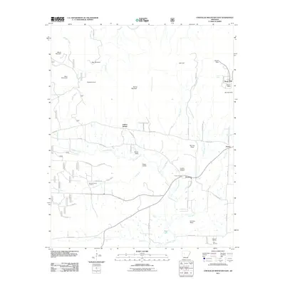
2011 Map of Chickalah Mountain East
USGS Topo · Published 2011About this map
The community of Chickalah serves as a central point in this Yell County landscape, situated where the Little Chickalah Creek meets the broader valley floor. To the northeast, the dramatic rise of Mount Nebo provides a prominent landmark, featuring distinct lookout points at Sunrise Point and Sunset Point. This area is characterized by several small rural settlements like Harkey Valley and Sulphur Springs, connected by an intricate network of county roads that navigate between ridges such as Mc Cray Ridge and Christian Ridge. Genealogists will find significant value in the distribution of local burial sites, including the Chickalah Methodist Cemetery, Fullton Cemetery, and the Mountain Spring Cemetery located near Rock Creek. The drainage patterns of the Gwin River and various branches like Jordan Branch and Carter Branch illustrate the hydrological backbone of this region, which remains largely rural and focused on small-town centers and crossroads like Mosley.
Find a feature on this map
63 named features on this map. Tap any name to fly to it.
Don’t see what you’re looking for? This feature index may not catch every label — zoom into the map to look around manually.
Map Details
Editions of this 2011 Chickalah Mountain East Map
This is the sole edition of this map. No revisions or reprints were ever made.
Other maps of this area

1888 · Dardanelle #4
USGS Topo · 1:62,500

1888 · Dardanelle #2
USGS Topo · 1:62,500

1888 · Dardanelle #1
USGS Topo · 1:62,500

1888 · Dardanelle #3
USGS Topo · 1:62,500

1890 · Dardanelle
USGS Topo · 1:125,000

1956 · Russellville
USGS Topo · 1:250,000
1962 · New Blaine
USGS Topo · 1:24,000

1962 · Delaware
USGS Topo · 1:24,000
1963 · Russellville West
USGS Topo · 1:24,000

1964 · Russellville
USGS Topo · 1:250,000