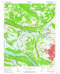
1963 Map of Russellville West
USGS Topo · Published 1964About this map
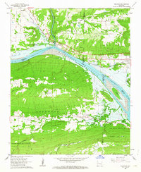
Arkansas Polytechnic College and the western reaches of Russellville anchor this mid-century look at the Arkansas River valley. The landscape is defined by the significant hydraulic engineering of the Dardanelle Reservoir and the Dardanelle Lock and Dam No 10, which transformed the Arkansas River during this era. An Indian Treaty Boundary line cuts through the center of the sheet, providing a direct link to the regional history of land division and settlement.
Find a feature on this map
61 named features on this map. Tap any name to fly to it.
Don’t see what you’re looking for? This feature index may not catch every label — zoom into the map to look around manually.
Map Details
Editions of this 1963 Russellville West Map
2 editions found

Other maps of this area

1888 · Dardanelle #4
USGS Topo · 1:62,500

1888 · Dardanelle #2
USGS Topo · 1:62,500

1888 · Dardanelle #1
USGS Topo · 1:62,500

1888 · Dardanelle #3
USGS Topo · 1:62,500

1890 · Dardanelle
USGS Topo · 1:125,000

1956 · Russellville
USGS Topo · 1:250,000
1961 · Dover
USGS Topo · 1:24,000
1962 · Knoxville
USGS Topo · 1:24,000
1962 · Russellville East
USGS Topo · 1:24,000
1962 · Delaware
USGS Topo · 1:24,000