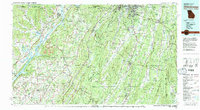
1981 Map of Chickamauga
USGS Topo · Published 1982About this map
Chickamauga and Chattanooga National Military Park anchors the northeast corner of this multi-state survey, marking the strategic terrain where the Tennessee River cuts through the ridges of the Cumberland Plateau. The landscape is dominated by the massive parallel formations of Lookout Mountain and Sand Mountain, which create deep valleys that shaped the settlement patterns of communities like Rising Fawn, Sulphur Springs, and Valley Head.
Find a feature on this map
88 named features on this map. Tap any name to fly to it.
Don’t see what you’re looking for? This feature index may not catch every label — zoom into the map to look around manually.
Map Details
Editions of this 1981 Chickamauga Map
2 editions found
Other maps of this area

1885 · Gadsden
USGS Topo · 1:125,000

1886 · Dalton
USGS Topo · 1:125,000

1886 · Cleveland
USGS Topo · 1:125,000

1886 · Ringgold
USGS Topo · 1:125,000

1886 · Rome
USGS Topo · 1:125,000

1886 · Stevenson
USGS Topo · 1:125,000

1888 · Gadsden
USGS Topo · 1:125,000

1888 · Chattanooga
USGS Topo · 1:125,000

1888 · Scottsboro
USGS Topo · 1:125,000

1890 · Cartersville
USGS Topo · 1:125,000