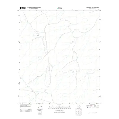
2012 Map of Chico Draw East
USGS Topo · Published 2012About this map
Triangle Ranch Private Airport serves as a lone aviation landmark in this arid stretch of Culberson County, marking the specialized infrastructure of West Texas ranching. The landscape is defined by its water management systems, essential for cattle operations in a region with sparse natural flow. A network of named basins, including Patterson Tank, Minnie Tank, and Nob Hill Tank, are connected by unpaved routes like Chico Rd and Stone Rd. These features illustrate the endurance of traditional land use and the vital role of artificial catchment in maintaining livestock. The distribution of these tanks, from Walker Tank in the west to Jack Tank further east, highlights the deliberate spacing required to support grazing across the desert flats during the early twenty-first century.
Find a feature on this map
13 named features on this map. Tap any name to fly to it.
Don’t see what you’re looking for? This feature index may not catch every label — zoom into the map to look around manually.
Map Details
Editions of this 2012 Chico Draw East Map
This is the sole edition of this map. No revisions or reprints were ever made.
Other maps of this area

1954 · Van Horn
USGS Topo · 1:250,000

1958 · Van Horn
USGS Topo · 1:250,000

1973 · Seven L Peak
USGS Topo · 1:24,000

1973 · K C Ranch
USGS Topo · 1:24,000

1973 · Chico Draw East
USGS Topo · 1:24,000

1973 · Cow Mountain
USGS Topo · 1:24,000

1973 · Burro Canyon
USGS Topo · 1:24,000

1973 · Delaware Spring
USGS Topo · 1:24,000
1973 · Emory Corral
USGS Topo · 1:24,000
1973 · Long Point
USGS Topo · 1:24,000