
1973 Map of K C Ranch
USGS Topo · Published 1976About this map
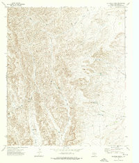
High-desert water management defines the landscape of Culberson County in the early 1970s. The region is characterized by a sparse network of ranching outposts and ephemeral drainage systems, most notably Emory Draw and Frijole Draw. Settlement is concentrated at the K C Ranch and Weatherby Ranch, which served as anchors for local agricultural activity. The map reveals the critical importance of water infrastructure in this arid environment, documenting a sophisticated system of wells and tanks such as Sulphur Well, Budweiser Well, and Sorghum Belt Tank. These features, alongside the evocative Dust Bowl Tank, reflect the historical struggle and ingenuity required to sustain livestock in the Trans-Pecos. The topography is marked by significant elevation changes, with the Weatherby area showing the varied relief of the Texas horizon.
Find a feature on this map
15 named features on this map. Tap any name to fly to it.
Don’t see what you’re looking for? This feature index may not catch every label — zoom into the map to look around manually.
Map Details
Editions of this 1973 K C Ranch Map
This is the sole edition of this map. No revisions or reprints were ever made.
Other maps of this area

1906 · Van Horn
USGS Topo · 1:125,000

1928 · Kent
USGS Topo · 1:125,000

1954 · Van Horn
USGS Topo · 1:250,000

1958 · Van Horn
USGS Topo · 1:250,000

1973 · Dellahunt Draw West
USGS Topo · 1:24,000

1973 · Seven L Peak
USGS Topo · 1:24,000

1973 · Two Mill Draw West
USGS Topo · 1:24,000

1973 · Seven L Peak NE
USGS Topo · 1:24,000

1973 · Chico Draw East
USGS Topo · 1:24,000
1973 · Delaware Ranch
USGS Topo · 1:24,000