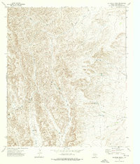
1973 Map of Delaware Ranch
USGS Topo · Published 1976About this map
Delaware Ranch sits at the heart of this high-desert landscape in Culberson County, where the terrain is defined by a complex network of canyons and draws. The map illustrates a region where water management was critical to ranching operations, as evidenced by numerous named water features like Goat Tank, St John Tank, and the naturally occurring Rock Water Hole. Significant drainage systems, including Maverick Canyon and Ed Ray Canyon, cut through the topography, channeling seasonal runoff toward Emory Draw and Frijole Draw. This 1970s survey captures the remote character of the Trans-Pecos, where a single Pipeline and a few rugged routes like the Jeep Trail represent the only modern infrastructure across the Cheatum uplands.
Find a feature on this map
18 named features on this map. Tap any name to fly to it.
Don’t see what you’re looking for? This feature index may not catch every label — zoom into the map to look around manually.
Map Details
Editions of this 1973 Delaware Ranch Map
This is the sole edition of this map. No revisions or reprints were ever made.
Other maps of this area

1906 · Van Horn
USGS Topo · 1:125,000

1928 · Kent
USGS Topo · 1:125,000

1954 · Van Horn
USGS Topo · 1:250,000

1958 · Van Horn
USGS Topo · 1:250,000

1972 · Seven Heart Gap
USGS Topo · 1:24,000

1972 · Square Mesa
USGS Topo · 1:24,000

1973 · K C Ranch
USGS Topo · 1:24,000
1973 · Dome Hill
USGS Topo · 1:24,000

1973 · Burro Canyon
USGS Topo · 1:24,000
1973 · Seven Heart Gap NW
USGS Topo · 1:24,000