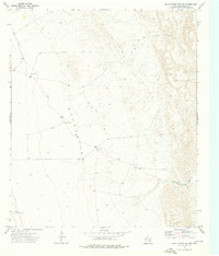
1973 Map of Seven Heart Gap NW
USGS Topo · Published 1976About this map
Essential water sources define this arid Culberson County landscape, mapped by the Geological Survey during the early 1970s. The topographic detail highlights a vast (Depression) that dominates the central portion of the sheet, where remote features like Ocotillo Tank and Ocotillo Well served as critical landmarks in a region largely devoid of permanent settlements. This area is characterized by sparse infrastructure, relying on a network of Jeep Trails for navigation between scattered outposts.
Find a feature on this map
9 named features on this map. Tap any name to fly to it.
Don’t see what you’re looking for? This feature index may not catch every label — zoom into the map to look around manually.
Map Details
Editions of this 1973 Seven Heart Gap NW Map
This is the sole edition of this map. No revisions or reprints were ever made.
Other maps of this area

1906 · Van Horn
USGS Topo · 1:125,000

1954 · Van Horn
USGS Topo · 1:250,000

1958 · Van Horn
USGS Topo · 1:250,000

1972 · Seven Heart Gap
USGS Topo · 1:24,000

1972 · Square Mesa
USGS Topo · 1:24,000
1973 · Victorio Peak
USGS Topo · 1:24,000

1973 · Bitter Well Mountain
USGS Topo · 1:24,000
1973 · Delaware Ranch
USGS Topo · 1:24,000

1973 · Burro Canyon
USGS Topo · 1:24,000
1973 · Emory Corral
USGS Topo · 1:24,000