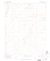
1970 Map of Chicos Well
USGS Topo · Published 1973About this map
The Huerfano River carves through this arid landscape of Pueblo County, where a complex network of 1970s water management features defines the terrain. At the heart of the area lies the Chicos Well, feeding into a series of drainages and reservoirs including Upper Chicosa and Lower Chicosa reservoirs. The infrastructure for agriculture is prominent, evidenced by the Nepesta Farmers Ditch and numerous tanks like the Alderd Tank. These features reflect a managed prairie environment where every water source, from the East Cox Windmill to the Fountain Well, was meticulously mapped to support the region's ranching or farming needs. Rising above the lowlands, the Hooker Hills and Butler Butte provide significant topographical relief in the northeastern corner, overlooking a patchwork of family-named water features such as McClain Res and Goodwin Res.
Find a feature on this map
25 named features on this map. Tap any name to fly to it.
Don’t see what you’re looking for? This feature index may not catch every label — zoom into the map to look around manually.
Map Details
Editions of this 1970 Chicos Well Map
2 editions found
Other maps of this area

1891 · Nepesta
USGS Topo · 1:125,000

1891 · Apishapa
USGS Topo · 1:125,000

1893 · Nepesta
USGS Topo · 1:125,000

1893 · Apishapa
USGS Topo · 1:125,000

1897 · Apishapa
USGS Topo · 1:125,000

1904 · Nepesta
USGS Topo · 1:125,000

1954 · Trinidad
USGS Topo · 1:250,000

1954 · Pueblo
USGS Topo · 1:250,000

1955 · Trinidad
USGS Topo · 1:250,000

1957 · Pueblo
USGS Topo · 1:250,000