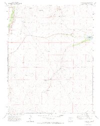
1970 Map of Chicos Well
USGS Topo · Published 1973About this map
The Huerfano River defines the western edge of this landscape, where the Welton Road runs parallel to the water through a valley floor marked by several irrigation and drainage systems. This 1970s record of Pueblo County shows a complex network of managed water sources, notably the Nepesta Farmers Ditch and numerous reservoirs such as Nepesta Reservoir No 5 and McFarland Res No 1. The presence of several flowing wells, including Chicos Well (Flowing) and Fountain Well (Flowing), highlights the vital role of groundwater management in this arid environment.
Find a feature on this map
29 named features on this map. Tap any name to fly to it.
Don’t see what you’re looking for? This feature index may not catch every label — zoom into the map to look around manually.
Map Details
Editions of this 1970 Chicos Well Map
2 editions found
Other maps of this area

1891 · Nepesta
USGS Topo · 1:125,000

1891 · Apishapa
USGS Topo · 1:125,000

1893 · Nepesta
USGS Topo · 1:125,000

1893 · Apishapa
USGS Topo · 1:125,000

1897 · Apishapa
USGS Topo · 1:125,000

1904 · Nepesta
USGS Topo · 1:125,000

1954 · Trinidad
USGS Topo · 1:250,000

1954 · Pueblo
USGS Topo · 1:250,000

1955 · Trinidad
USGS Topo · 1:250,000

1957 · Pueblo
USGS Topo · 1:250,000