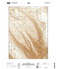
2020 Map of Chignik A-7 SE
USGS Topo · Published 2020About this map
The Aleutian Range dominates this landscape in the Aleutians East Borough, where steep topographic contours reveal the dramatic rise of the volcanic peninsula. This high-altitude terrain serves as a critical drainage divide for local waterways, most notably the Spirit River in the northeast and the Milky River in the southwest. The mapping of the township and range lines, including t47s r70w, t47s r69w, t48s r70w, and t48s r69w, provides a structural framework for this otherwise unpopulated wilderness. The glacial or snow-fed character of these river systems is typical of the region, where the network of smaller streams and unnamed lakes feeds into these larger glacial arteries.
Find a feature on this map
7 named features on this map. Tap any name to fly to it.
Don’t see what you’re looking for? This feature index may not catch every label — zoom into the map to look around manually.
Map Details
Editions of this 2020 Chignik A-7 SE Map
This is the sole edition of this map. No revisions or reprints were ever made.
Other maps of this area

1951 · Stepovak Bay
USGS Topo · 1:250,000

1953 · Port Moller
USGS Topo · 1:250,000

1963 · Chignik A-6
USGS Topo · 1:63,360

1963 · Chignik A-7
USGS Topo · 1:63,360

1963 · Stepovak Bay D-6
USGS Topo · 1:63,360

1963 · Chignik
USGS Topo · 1:250,000

1963 · Stepovak Bay
USGS Topo · 1:250,000
1963 · Port Moller D-1
USGS Topo · 1:63,360

1969 · Stepovak Bay
USGS Topo · 1:250,000

1988 · Port Moller
USGS Topo · 1:250,000