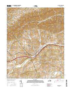
2016 Map of Chilhowie
USGS Topo · Published 2016About this map
Chilhowie serves as the central hub of this Southwest Virginia landscape, situated along the Middle Fork Holston River where the Norfolk Southern line parallels the valley floor. The settlement pattern is defined by the tight corridors between Walker Mtn to the north and the river to the south, with numerous family and community burial grounds like Aspenvale Cem and Sulphur Spring Cem dotting the hillsides. The transition from industrial areas near Industrial Park Rd to the more rural stretches near Seven Mile Ford illustrates the area's continued reliance on its transportation corridors.
Find a feature on this map
123 named features on this map. Tap any name to fly to it.
Don’t see what you’re looking for? This feature index may not catch every label — zoom into the map to look around manually.
Map Details
Editions of this 2016 Chilhowie Map
This is the sole edition of this map. No revisions or reprints were ever made.
Other maps of this area

1891 · Abingdon
USGS Topo · 1:125,000

1894 · Abingdon
USGS Topo · 1:125,000

1909 · Abingdon
USGS Topo · 1:96,000

1911 · Abingdon
USGS Topo · 1:125,000
1934 · Chatham Hill
USGS Topo · 1:24,000

1935 · Konnarock
USGS Topo · 1:24,000

1935 · Chilhowie
USGS Topo · 1:24,000
1935 · Maccrady
USGS Topo · 1:24,000

1935 · Mount Rogers
USGS Topo · 1:48,000
1935 · Saltville
USGS Topo · 1:24,000