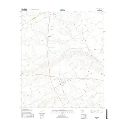
2016 Map of Chilton
USGS Topo · Published 2016About this map
Chilton and Satin anchor this rural landscape in western Falls County, where the topography is defined by the winding course of Cow-Bayou and its various tributaries. The settlement of Golinda straddles the boundary with McLennan County to the north, while North Prairie sits just to its south. The area’s hydrology is particularly complex, featuring man-made improvements such as the Soil Conservation Service Site 30 Reservoir and the Red Ditch near the banks of the Brazos River. Local family history is preserved at the Cedar Valley Cemetery, situated near Post Oak Creek on the eastern edge of the quadrangle. The map details a network of farm-to-market roads and county routes that connect these small communities, crossing waterways like Bull-Hide Creek, Deer Creek, and Little Deer Creek.
Find a feature on this map
71 named features on this map. Tap any name to fly to it.
Don’t see what you’re looking for? This feature index may not catch every label — zoom into the map to look around manually.
Map Details
Editions of this 2016 Chilton Map
This is the sole edition of this map. No revisions or reprints were ever made.
Other maps of this area

1892 · Temple
USGS Topo · 1:125,000

1954 · Waco
USGS Topo · 1:250,000

1955 · Waco
USGS Topo · 1:250,000

1957 · Bruceville
USGS Topo · 1:24,000

1957 · Lorena
USGS Topo · 1:24,000

1957 · Riesel
USGS Topo · 1:24,000

1957 · Chilton
USGS Topo · 1:24,000

1957 · Marlin
USGS Topo · 1:24,000
1957 · Robinson
USGS Topo · 1:24,000

1962 · Cedar Springs
USGS Topo · 1:24,000