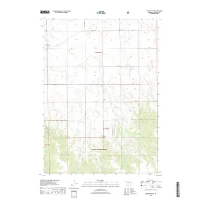
2017 Map of Chimney Butte
USGS Topo · Published 2017About this map
Nebraska National Forest dominates the southern landscape of this Dawes County survey, where the rugged topography of the Pine Ridge region transitions into the northern plains. This area is defined by its distinct landforms, most notably Chimney Butte and Barrel Butte, which serve as primary landmarks for navigation. The drainage network is dense, with numerous watercourses such as Trunk Butte Cr, Little Spring Cr, and Cunningham Cr carving through the terrain. A sparse network of rural roads, including Bethel Rd and Haynes Rd, connects the scattered homesteads of this ranching country. Central to the local history of the area is Bethel Cem, located just off the main road, providing a focal point for genealogical research in this sparsely populated portion of the state.
Find a feature on this map
24 named features on this map. Tap any name to fly to it.
Don’t see what you’re looking for? This feature index may not catch every label — zoom into the map to look around manually.
Map Details
Editions of this 2017 Chimney Butte Map
This is the sole edition of this map. No revisions or reprints were ever made.
Other maps of this area

1955 · Alliance
USGS Topo · 1:250,000

1957 · Alliance
USGS Topo · 1:250,000

1958 · Alliance
USGS Topo · 1:250,000

1980 · Crow Butte
USGS Topo · 1:24,000
1980 · Coffee Mill Butte SE
USGS Topo · 1:24,000
1980 · Coffee Mill Butte
USGS Topo · 1:24,000
1980 · Coffee Mill Butte SW
USGS Topo · 1:24,000
1980 · Trunk Butte
USGS Topo · 1:24,000
1980 · Chimney Butte
USGS Topo · 1:24,000
1980 · Belmont
USGS Topo · 1:24,000