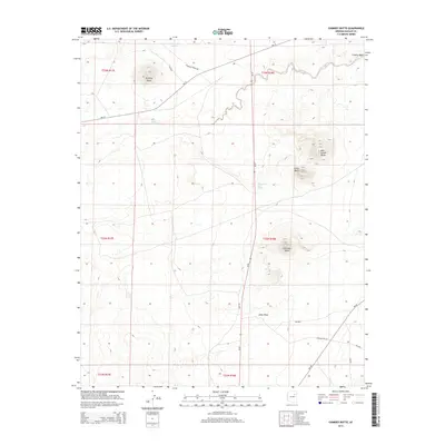
2014 Map of Chimney Butte
USGS Topo · Published 2014About this map
Chimney Butte and a series of prominent volcanic landforms dominate this high-desert landscape within the Navajo Nation. At the time of this 2014 survey, the region remains defined by its water sources and isolated elevations, including Pyramid Butte and Castle Butte. The network of Bureau of Indian Affairs roads, such as Bia-15 and Bia-60, provides the primary access through the townships, connecting the scattered springs that sustain the area. Chandler Springs and Red Cheek Spring are critical points of interest for understanding the historical and modern reliance on groundwater in this arid terrain. Seasonal drainages like Coyote Wash and Johns Draw further illustrate the topographical character of the land, showing how water shapes the passage through the desert between the distinct buttes.
Find a feature on this map
25 named features on this map. Tap any name to fly to it.
Don’t see what you’re looking for? This feature index may not catch every label — zoom into the map to look around manually.
Map Details
Editions of this 2014 Chimney Butte Map
This is the sole edition of this map. No revisions or reprints were ever made.
Other maps of this area

1883 · Tusayan
USGS Topo · 1:250,000

1886 · Tusayan
USGS Topo · 1:250,000

1947 · Flagstaff
USGS Topo · 1:250,000

1954 · Winslow
USGS Topo · 1:62,500

1954 · Winslow 4 NE
USGS Topo · 1:24,000

1954 · Flagstaff
USGS Topo · 1:250,000

1958 · Flagstaff
USGS Topo · 1:250,000

1960 · Flagstaff
USGS Topo · 1:250,000

1962 · Flagstaff
USGS Topo · 1:250,000
1967 · Dilkon
USGS Topo · 1:24,000