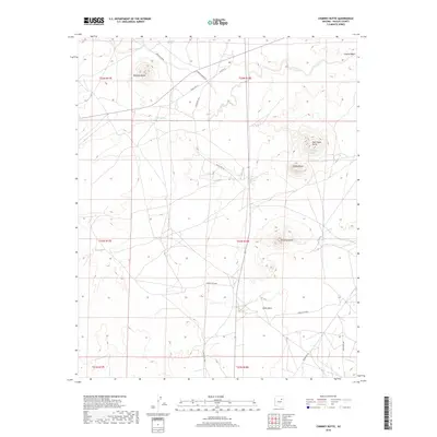
2018 Map of Chimney Butte
USGS Topo · Published 2018About this map
Chimney Butte and its namesake spring anchor this arid landscape within the Fort Defiance Agency, characterized by isolated landforms and a network of traditional travel routes. The map documents a terrain defined by geological monuments such as Castle Butte, Red Cheek Butte, and Pyramid Butte. These landmarks serve as critical navigational points across a network of roads including Chandler Spring Rd and Old Rte 15. Water sources are few and significant, appearing as scattered points like Chandler Springs and Coyote Spring. The drainage patterns of Johns Draw and Coyote Wash illustrate how the environment is shaped by seasonal runoff. This survey provides a precise look at the rural infrastructure of the late 2010s, tracing a series of Bureau of Indian Affairs routes such as Indian Rte 156 and Indian Rte 9855 that connect this remote high-desert region.
Find a feature on this map
26 named features on this map. Tap any name to fly to it.
Don’t see what you’re looking for? This feature index may not catch every label — zoom into the map to look around manually.
Map Details
Editions of this 2018 Chimney Butte Map
This is the sole edition of this map. No revisions or reprints were ever made.
Other maps of this area

1883 · Tusayan
USGS Topo · 1:250,000

1886 · Tusayan
USGS Topo · 1:250,000

1947 · Flagstaff
USGS Topo · 1:250,000

1954 · Winslow
USGS Topo · 1:62,500

1954 · Winslow 4 NE
USGS Topo · 1:24,000

1954 · Flagstaff
USGS Topo · 1:250,000

1958 · Flagstaff
USGS Topo · 1:250,000

1960 · Flagstaff
USGS Topo · 1:250,000

1962 · Flagstaff
USGS Topo · 1:250,000
1967 · Dilkon
USGS Topo · 1:24,000