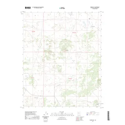
2023 Map of Chimney Hill
USGS Topo · Published 2023About this map
Chimney Hill rises as a prominent landmark in this high-desert landscape of Cibola County, where seasonal waters and ephemeral drainage patterns define the local geography. The map illustrates a series of small, intermittent water bodies including Laguna Large, La Baca Lake, and Mantequilla Lake, which reflect the region's reliance on localized runoff. These basins, along with Carpenter Lake and Chimney Lake, are critical points in an arid environment otherwise dominated by sweeping drainage features like Puertocito Draw and the Lorenzo Arroyo.
Find a feature on this map
19 named features on this map. Tap any name to fly to it.
Don’t see what you’re looking for? This feature index may not catch every label — zoom into the map to look around manually.
Map Details
Editions of this 2023 Chimney Hill Map
This is the sole edition of this map. No revisions or reprints were ever made.
Other maps of this area

1954 · Saint Johns
USGS Topo · 1:250,000

1957 · Saint Johns
USGS Topo · 1:250,000

1958 · Saint Johns
USGS Topo · 1:250,000

1962 · Saint Johns
USGS Topo · 1:250,000

1967 · Red Lake Mission
USGS Topo · 1:24,000

1967 · Chimney Hill
USGS Topo · 1:24,000

1967 · Cerro Alto
USGS Topo · 1:24,000

1967 · Veteado Mountain
USGS Topo · 1:24,000
1967 · Cerro Pomo
USGS Topo · 1:24,000
1967 · Techado
USGS Topo · 1:24,000