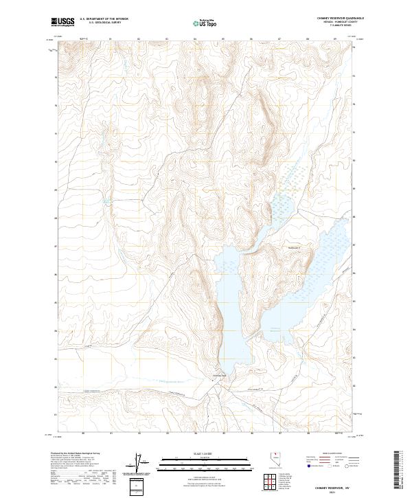
2021 Map of Chimney Reservoir
USGS Topo · Published 2021About this map
Chimney Reservoir serves as the central focal point for this high-desert basin in Humboldt County. Fed by the waters of Chimney Cr and the Little Humboldt River, this basin is a critical water source for the surrounding arid landscape. The topography is defined by significant landmarks like Chimney Peak to the south and the northern drainage of the N Fork Little Humboldt River. Transportation through this remote section of Nevada is limited to unpaved access routes such as N Fork Rd and Chimney Reservoir Rd, which skirt the edges of the water and provide access to smaller impoundments like Fairbanks Reservoir. The mapping of these river forks and creeks, including Twentytwo Cr, reveals the intricate natural drainage patterns that have shaped land use and ranching access in this region for generations.
Find a feature on this map
19 named features on this map. Tap any name to fly to it.
Don’t see what you’re looking for? This feature index may not catch every label — zoom into the map to look around manually.
Map Details
Editions of this 2021 Chimney Reservoir Map
This is the sole edition of this map. No revisions or reprints were ever made.
Other maps of this area

1882 · Paradise
USGS Topo · 1:250,000

1893 · Paradise
USGS Topo · 1:250,000

1945 · Hot Springs
USGS Topo · 1:62,500

1947 · Hot Springs Peak
USGS Topo · 1:62,500

1955 · McDermitt
USGS Topo · 1:250,000

1959 · McDermitt
USGS Topo · 1:250,000
1980 · Layton Spring
USGS Topo · 1:24,000

1980 · Hardscrabble
USGS Topo · 1:24,000
1980 · Kenny Creek
USGS Topo · 1:24,000
1980 · Chimney Reservoir
USGS Topo · 1:24,000