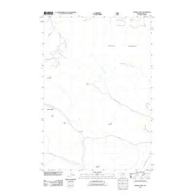
2011 Map of Chimney Rock
USGS Topo · Published 2011About this map
Maxey Mines and the individual Maxey Mine stand as prominent markers of the extraction history near the base of Chimney Rock in Park County. This 2011 survey illustrates a mountain landscape where family-named holdings like Blome Ranch and Nesbit Ranch are situated along the drainage of Trail Creek. The map documents a rugged topography defined by notable elevations including Canyon Mountain, Wineglass Mountain, and the distinct ridge known as The Hogback. Transportation routes are sparse, though the southern edge features the Old Yellowstone Trl N, a road name that evokes the historic gateway to the national park. Smaller watercourses such as Eagle Creek and Strickland Creek carve through the terrain, connecting the high ridges of Pine Mountain to the valleys below.
Find a feature on this map
37 named features on this map. Tap any name to fly to it.
Don’t see what you’re looking for? This feature index may not catch every label — zoom into the map to look around manually.
Map Details
Editions of this 2011 Chimney Rock Map
This is the sole edition of this map. No revisions or reprints were ever made.
Other maps of this area

1891 · Livingston
USGS Topo · 1:250,000

1893 · Livingston
USGS Topo · 1:250,000

1947 · Bozeman
USGS Topo · 1:250,000

1948 · Bozeman
USGS Topo · 1:250,000

1951 · Bozeman Pass
USGS Topo · 1:62,500

1951 · Brisbin
USGS Topo · 1:24,000

1951 · Hoppers
USGS Topo · 1:24,000

1951 · Chimney Rock
USGS Topo · 1:24,000
1951 · Livingston
USGS Topo · 1:24,000

1955 · Bozeman
USGS Topo · 1:250,000