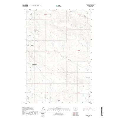
2020 Map of Chimney Rock
USGS Topo · Published 2020About this map
Paradise Valley marks the southeastern corner of this map, where the irrigation infrastructure of the Park Br Canal and Highline Ditch supports the local agriculture. The terrain is dominated by prominent summits including Canyon Mtn, Wineglass Mtn, and the distinctive Chimney Rock formation. This landscape is defined by its drainage systems, with Strickland Cr and Trail Cr cutting through the high country. Historical transportation routes are evident in the naming of Old Yellowstone Trl N, which follows the lower valley, while higher elevations are accessed via named routes like Trail Creek Rd and Strickland Creek Rd. Smaller geographic landmarks such as Bears Den, Buffalo Gap, and The Hogback provide specific points of interest for those studying the natural features and early trail networks of this part of Park County.
Find a feature on this map
51 named features on this map. Tap any name to fly to it.
Don’t see what you’re looking for? This feature index may not catch every label — zoom into the map to look around manually.
Map Details
Editions of this 2020 Chimney Rock Map
This is the sole edition of this map. No revisions or reprints were ever made.
Other maps of this area

1891 · Livingston
USGS Topo · 1:250,000

1893 · Livingston
USGS Topo · 1:250,000

1947 · Bozeman
USGS Topo · 1:250,000

1948 · Bozeman
USGS Topo · 1:250,000

1951 · Bozeman Pass
USGS Topo · 1:62,500

1951 · Brisbin
USGS Topo · 1:24,000

1951 · Hoppers
USGS Topo · 1:24,000

1951 · Chimney Rock
USGS Topo · 1:24,000
1951 · Livingston
USGS Topo · 1:24,000

1955 · Bozeman
USGS Topo · 1:250,000