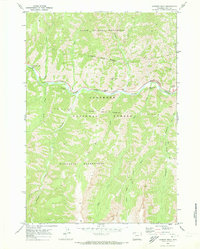
1970 Map of Chimney Rock
USGS Topo · Published 1973About this map
The North Fork Shoshone River carves a deep path through the heart of the Shoshone National Forest, creating a corridor of activity in a landscape defined by sharp elevation changes and dramatic geological formations. Along the river, landmarks such as The Palisades, Elephant Head Rock, and Chimney Rock highlight the unique topography of the canyon. This 1970 survey captures the area’s role as a gateway to the high country, with the Wayfarers Chapel and Buffalo Bill Camp serving as focal points for travelers and residents along the road to Yellowstone. North and south of the river corridor, the terrain transitions into the North Absaroka Wilderness and Washakie Wilderness. A network of historic paths, including the Fire Memorial Trail (Pack), provides access to the remote backcountry where numerous creeks like Fishhawk Creek and Blackwater Creek drain the surrounding heights.
Find a feature on this map
26 named features on this map. Tap any name to fly to it.
Don’t see what you’re looking for? This feature index may not catch every label — zoom into the map to look around manually.
Map Details
Editions of this 1970 Chimney Rock Map
2 editions found
Other maps of this area

1893 · Ishawooa
USGS Topo · 1:125,000

1895 · Ishawooa
USGS Topo · 1:125,000

1896 · Crandall Creek
USGS Topo · 1:125,000

1899 · Crandall
USGS Topo · 1:125,000

1899 · Ishawooa
USGS Topo · 1:125,000

1955 · Cody
USGS Topo · 1:250,000

1956 · Sunlight Peak
USGS Topo · 1:62,500

1956 · Dead Indian Peak
USGS Topo · 1:62,500

1958 · Cody
USGS Topo · 1:250,000

1962 · Cody
USGS Topo · 1:250,000