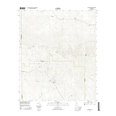
2014 Map of China Grove
USGS Topo · Published 2014About this map
China Grove sits at the convergence of several rural routes including China Grove Rd and Meriwether Trl, marking a historical anchor point where Bullock and Pike Counties meet. This landscape is defined by the headwaters of numerous small waterways, such as China Grove Cr, Panther Cr, and Mannings Cr, which weave between small settlements and family burial grounds. The distribution of sites like Edwards Cem, China Grove Cem, and Dennis Cem reflects a deeply rooted community structure maintained through generations. Along the northern edge, Us-82 connects the hamlets of Shopton and Hector, while the central wooded elevations around McGowan provide a natural buffer between the agricultural tracts of the surrounding counties. The prevalence of old roads like Old Pike Rd and Old Union Rd suggests long-standing transit patterns through this corner of Alabama.
Find a feature on this map
43 named features on this map. Tap any name to fly to it.
Don’t see what you’re looking for? This feature index may not catch every label — zoom into the map to look around manually.
Map Details
Editions of this 2014 China Grove Map
This is the sole edition of this map. No revisions or reprints were ever made.
Other maps of this area
1953 · Montgomery
USGS Topo · 1:250,000
1953 · Andalusia
USGS Topo · 1:250,000
1953 · Dothan
USGS Topo · 1:250,000
1954 · Dothan
USGS Topo · 1:250,000
1955 · Dothan
USGS Topo · 1:250,000
1955 · Phenix City
USGS Topo · 1:250,000
1956 · Montgomery
USGS Topo · 1:250,000
1957 · Phenix City
USGS Topo · 1:250,000
1957 · Montgomery
USGS Topo · 1:250,000
1957 · Andalusia
USGS Topo · 1:250,000