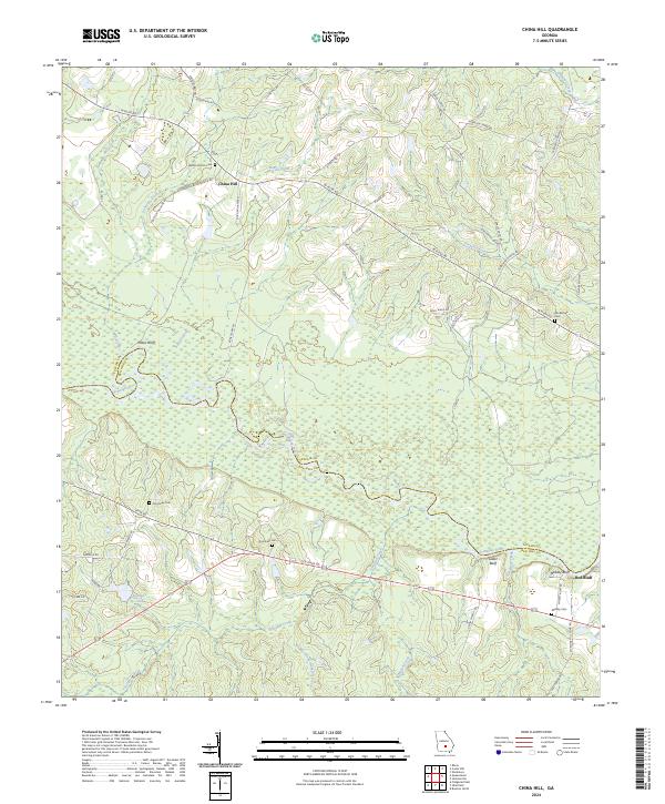
2024 Map of China Hill
USGS Topo · Published 2024About this map
The Ocmulgee River carves a serpentine path through the heart of this South Georgia landscape, defining the winding boundary between Telfair and Ben Hill counties. This modern topographic study reveals a rural mosaic of river bluffs and creek bottoms, where the small settlement of China Hill sits at a junction of roads such as China Hill Rd and Raymond Bloodworth Rd. For those tracing family ties to the area, several burial grounds are preserved across the terrain, including Bethel Church Cem, Blockhouse Cem, and Dorminey Cem. The drainage patterns are intricate, with Sturgeon Creek, Boney Creek, and Mill Creek feeding into the main river channel. Along the southern banks, prominent elevations like Yellow Bluff, Gilder Bluff, and Mobley Bluff overlook the wetlands and the isolated community of Red Bluff near the eastern margin.
Find a feature on this map
57 named features on this map. Tap any name to fly to it.
Don’t see what you’re looking for? This feature index may not catch every label — zoom into the map to look around manually.
Map Details
Editions of this 2024 China Hill Map
This is the sole edition of this map. No revisions or reprints were ever made.
Other maps of this area

1953 · Waycross
USGS Topo · 1:250,000

1958 · Waycross
USGS Topo · 1:250,000

1972 · Cooks Still
USGS Topo · 1:24,000

1972 · Broxton North
USGS Topo · 1:24,000

1972 · Jacksonville
USGS Topo · 1:24,000

1972 · Fitzgerald East
USGS Topo · 1:24,000

1972 · China Hill
USGS Topo · 1:24,000
1972 · Workmore
USGS Topo · 1:24,000

1972 · Queensland
USGS Topo · 1:24,000

1977 · Osierfield
USGS Topo · 1:24,000