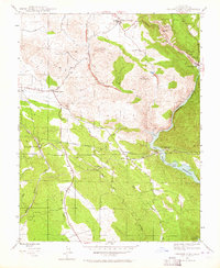
1947 Map of Chinese Camp
USGS Topo · Published 1964About this map
The Red Hills dominate the central landscape of this Gold Country survey, defined by complex mining infrastructure and early water transport systems. Along the northern edge, Chinese Camp serves as a primary settlement hub, while the eastern border reveals a dense concentration of industrial sites, including the Eagle-Shawmut Mine and its accompanying Eagle-Shawmut Mill. The mapping of the Hetch Hetchy Aqueduct and the Red Mountain Bar Siphon illustrates the massive engineering efforts required to move water toward the coast.
Find a feature on this map
28 named features on this map. Tap any name to fly to it.
Don’t see what you’re looking for? This feature index may not catch every label — zoom into the map to look around manually.
Map Details
Editions of this 1947 Chinese Camp Map
4 editions found
Other maps of this area

1893 · Sonora
USGS Topo · 1:125,000

1896 · Sonora
USGS Topo · 1:125,000

1897 · Sonora
USGS Topo · 1:125,000

1898 · Sonora
USGS Topo · 1:125,000

1915 · La Grange
USGS Topo · 1:24,000

1916 · Cooperstown
USGS Topo · 1:31,680

1916 · Copperopolis
USGS Topo · 1:62,500

1919 · La Grange
USGS Topo · 1:31,680

1942 · Copperopolis
USGS Topo · 1:62,500

1944 · Merced Falls
USGS Topo · 1:62,500